
Columns: Name, County, Page, Township
- Brooks, Anthony S. Muskingum, 158, Jefferson
- Brooks, Caleb, Muskingum, 331, Jackson - grandpa
- Brooks, David . Licking, 329, Liberty
- Brooks, Hiram, Muskingum, 335, Jackson
- Brooks, James, Muskingum, 80, Clay
- Edward, Jacob, Muskingum, 291, Madison
- Edward, Job, Licking, 222, Hartford
- Edward, John, Licking, 238, Hartford
- Edward, John, Licking 151, Union
- Edwards, Charles H., Muskingum, 359, Perry
- Edwards, David, Muskingum, 121, W. Zanesville
- Edwards, David, Muskingum, 114, Falls
- Edwards, David, Licking, 273, Harrison
- Edwards, Ellen, Licking, 50, Newark
- Edwards, Ellen, Licking, 10, Newark
- Edwards, Henry, Licking, 23, Newark
- Edwards, Henry, Muskingum, 249, Zanesville
- Edwards, J.B. Licking, 297, Lima
- Edwards, J.D., Licking, 247, Bennington
- Edwards, J.S. Licking, 46, Newark
- Edwards, Jabes, Licking, 422, Burlington
- Edwards, Jabez, Licking, 22, Newark
- Edwards, Jane, Muskingum, 291, Madison
- Edwards, Jessee, Licking, 269, McKean
- Edwards, John, Licking, 273, Harrison
- Edwards, John, Muskingum, 346, Licking
- Edwards, John, Licking, 164, Union
- Edwards, John W. Muskingum, 125, Newton
- Edwards, John W. Muskingum, 125, Newton
- Edwards, Joshua, Licking, 164, Union
- Edwards, Lewis, Licking, 452, Newton
- Edwards, Lucy, Licking, 65, Granville
- Edwards, Margaret, Licking, 165, Union
- Edwards, Maria, Muskingum, 189, Zanesville
- Edwards, Maria, Muskingum, 187, Zanesville
- Edwards, Maria, Licking, 413, Utica
- Edwards, Mary, Licking, 272, Harrison
- Edwards, Mordica, Muskingum, 321, Adams - uncle
- Edwards, Robert, Licking, 422, Burlington
- Edwards, Silas, Licking, 419, Washington
- Edwards, Thomas, Licking, 27, Newark
- Edwards, Thomas, Muskingum, 355 Licking
- Edwards, Thomas W. Licking, 381, Mary Ann
- Edwards, Timothy, Licking, 248, Bennington
- Edwards, Waller, Licking, 393, Eden
- Edwards, William, Licking, 79, Granville
- Edwords, J.B., Licking, 297, Lima
- Parks, David, Coshocton, 58, Washington
- Parks, David, Coshocton, 117, Virginia
- Parks, George, Licking, 6, Newark
- Parks, George, Coshocton, 183, Monroe
- Parks, H.W., Licking, 19, Newark
- Parks, Jonathan, Coshocton, 147, Jackson
- Parks, Joseph, Coshocton, 83, Perry
- Parks, Joseph, Coshocton, 389, Huntington
- Parks, Samuel, Coshocton, 111, Virginia
- Parks, William, Coshocton, 58, Washington
- Parks, William, Muskingum, 325, Jackson
First Census of the United States, 1790, Ohio North West Territorial Census Index, no imprint
The first U.S. federal census was taken as the result of the Constitution, Article I, section 2 which states:
Representatives and direct taxes shall be apportioned among the several States which may be included within this Union according to their respective numbers, which shall be determined by adding to the whole number of free persons, including those bound to service for a term of years, and excluding Indians not taxed, three-fifths of all other persons. The actual enumeration shall be made within three years after the first meeting of the Congress of the United States, and within every subsequent term of the years, in such manner as they shall be law direct.
The task of taking the enumeration was to begin on the first Monday in August 1790 and close within nine months, at which time the marshals were to make their returns. In the case of persons having no settled place of residence the act stated that they should be listed in the division where they happened to be on the first day of August.
- Names of heads of families
- Free white males of 16 and upwards including heads of families
- Free white males under 16
- Free white females, including heads of families
- All other free persons
- Slaves
Enumerations were taken in the thirteen original states: Massachusetts, New Hampshire, Connecticut, Rhode Island, New York, New Jersey, Pennsylvania, Delaware, Maryland, Virginia, North Carolina, South Carolina and Georgia. Enumerations were taken for Vermont which became a state in 1791; Maine which was part of Massachusetts; Kentucky which was part of Virginia, and the present states of Alabama & Mississippi which were parts of Georgia. There was also a census of the present state of Tennessee which was part of North Carolina in 1790 but was organized as the Southwest Territory soon thereafter.
The present states of Ohio, Indiana, Illinois, Michigan, and Wisconsin, as well as part of Minnesota were known as the Northwest Territory, but there seems to have been little effort to take a census there. In the printed enumeration totals, blanks were provided for the Northwest Territory, but they were not filled in.
Unfortunately, some of the early census schedules had been lost or destroyed and could not be found by the Census Bureau in 1907. Those missing are for the states of Delaware, Georgia, Kentucky, New Jersey, Tennessee (Southwest Territory) and Virginia.
Chronological Creation of the U.S. Territories:
- Virginia 1607, statehood 25 Jun 1788
- Massachusetts 1620, statehood 28 Apr. 1788
- Connecticut 1633, statehood 9 Jan. 1788
- Maryland 1634, statehood 28 April 1788
- Delaware 1638, statehood 7 Dec. 1787185
- North Carolina 1653, statehood 21 Nov. 1789
- Vermont 1665, statehood 4 Mar. 1791
- South Carolina 1670, statehood 23 May 1788
- Pennsylvania 1681, statehood 12 Dec. 1787
- Northwest Territory 13 July 1787, statehood 1 Mar. 1803 (for Ohio)
- Southwest Territory 26 May 1790, statehood 1 June 1796 (for Tennessee)
- Kentucky 26 May 1790, statehood 1 June 1792
- Indiana 7 May 1800, statehood 11 Dec. 1816
- Missouri 4 Jun 1812, statehood 10 Aug. 1821
- Illinois 3 Feb. 1809, statehood 3 Dec. 1818
- West Virginia 11 Jun. 1861, statehood 20 June 1863
Ohio Counties:
- Adams formed 10 July 1797 from Hamilton
- Allen formed 12 Feb. 1820 from Shelby
- Butler formed 24 Marc. 1803 from Hamilton
- Clermont formed 6 Dec. 1800 from Hamilton
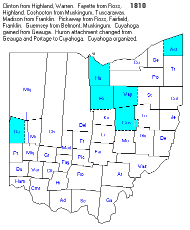
- Coshocton formed 31 Jan. 1810 from Muskingum & Tuscarawas
- Cuyahoga formed 10 Feb. 1808 from Geauga
- Franklin formed 30 Mar. 1803 from Ross & Wayne
- Gallia formed 25 Mar. 1803 from Washington & Adams
- Geauga formed 31 Dec. 1805 from Trumbull
- Hamilton formed 2 Jan. 1790 the second county formed
- Holmes formed 20 Jun 1824 from Coshocton, Wayne & Tuscarawas
- Jackson formed 12 Jan. 1815 from Scioto, Gallia, Athens & Ross
- Jefferson formed 27 July 1797 from Washington
- Lawrence formed 21 Dec. 1815 from Gallia & Scioto
- Licking formed 30 Jan. 1808 from Fairfield
- Lucas formed 20 Jun. 1835 from Wood, Sandusky & Henry
- Montgomery formed 24 Mar. 1803 from Hamilton & Wayne
- Morrow formed 24 Feb. 1848 from Knox, Delaware, Marion & Richland
- Muskingum formed 7 Jan. 1804 from Washington & Fairfield
- Scioto formed 24 Mar 1803 from Adams
- Shelby formed 7 Jan. 1819 from Miami
- Stark formed 13 Feb. 1808 from Columbiana
- Summit formed 3 Mar. 1840 from Portage, Medina & Stark
- Tuscarawas formed 13 Feb. 1808 from Muskingum
- Washington formed 27 July 1788 from Northwest Territory
- Brooks, Abner, Washington Co., OH, territorial residents 1790
- Brooks, J. Washington Co., OH, territorial residents 1790
- Clark, Arnold, Washington Co., OH, county residents 1790
- Clark, Joseph, Washington Co., OH, county residents 1790
- Clark, Joseph, Washington Co., OH, territorial residents 1790
- Ogle, Benjamin, Randolph Co., IL, Kaskaskia 1790
- Ogle, Benjamin, St. Clair Co., IL, no township listed, 1790
- Ogle, Jacog (?), St. Clair Co., IL, no township listed 1790
- Ogle, [J]oseph (?), Randolph Co., IL, Kaskaskia, 1790
- Porter, Amos, Ohio Territory, territorial residents 1790
- Porter, Amos, Jr. Washington Co., OH, organized settlement
- Porter, Benjamin Jones, Washington Co., OH, territorial resident
- Porter, Billy, Washington Co., OH, territorial resident
- Porter, Ebenezer, Washington Co., OH, county residents
- Porter, Enos, Hamilton Co. OH, Cincinnati
- Porter, John, Randolph Co., IL, Kaskaskia
- Porter, John, Hamilton Co., OH, county residents
- Porter, Samuel, Washington Co., OH county residents
- Porter, Thomas, Washington Co., OH county residents
- Shepard, William, Washington Co., OH, territorial residents
- Shepherd, Enoch, Washington Co., OH, county residents
- Shepherd, Enoch Jr. Washington Co., OH, county residents
- Shepherd, Enoch, Col., Washington Co., OH, residents of Marietta
- Shepherd, John, Washington Co., OH, county residents
- Wilson, George, Washington Co., OH, county residents
- Wilson, Jeremiah, Washington Co., OH, county residents
- Wilson, William, Washington Co., OH, county residents
Fisher, Jane. Monocacy Valley, 1707-1743, The Report, Vol. XIX, No. 4, Mansfield, OH: The Ohio Genealogical Society, Winter, 1979
Record of Explorers, Squatters, and Settlers in Monocacy Valley 1707-1743 - The following is copied from a private printing called Notes from the Records of Old Monocacy by Grace L. Tracy found in the public library in Frederick, Maryland. As many researchers in Ohio seem to be interested in Maryland, particularly Frederick County, it is felt that the following may be of interest.
- 1732 - Jan. 12 - John Beall
- 1737 - Apr. 5 - The Ogles
- 1738 - Jan. 17 - George Henckle
Fisher, Jane. More About Monocacy Valley, The Report, Vol. XX, No. 1, Mansfield, OH: The Ohio Genealogical Society, Summer, 1980
By 1743, 109,326 acres of Monocacy Valley had been surveyed, much for land speculators who leased it to German settlers.
The Manor of Monocacy, Lord Baltimore's own manor, was set aside for the building of a community whose settlers would pay rents directly to agents of Lord Baltimore. In 1738, Lord Baltimore established rules of payment on these leases: payment was to be in silver, gold, or such commodities as were agreed upon by Baltimore's agents. The system, known as "Seisen," somewhat resembled our land contract method of land purchase.
The Manor of Monocacy extended from south of Glade Creek to a point one mile east of present-day Woodsboro, bounded on the east by Laurel Hills and on the west by the Monocacy River. IT was the northern-most survey in the area, now part of Carroll County [MD], which was formerly Frederick County. Much of this area was in land in dispute before the Mason-Dixon Line was established. . . .
Following is an account of some of the people living on Monocacy Manor or in Monocacy Valley, the dates of settlement, and genealogical information gathered from various sources. Also included are titles given land tracts.
Lots on Monocacy Manor in 1741 and 1742 were occupied by the following families: Wm. Wilson, John Bell,
Wm. Fitzgerald, 1721: 2800 acres "Hope"; assigned to Richard Bennett in 1723
Joseph Ogle: "Hog Hill" and in 1751 "Grazing Ground
Jackson, Ronald & Gary Teeples, ed. Ohio 1840 Census Index, Bountiful, UT: Accelerated Indexing Systems, Inc., nd

Columns: Name, County, Page, Township
- Brooks, Caspar, Muskingum, 436, Perry
- Brooks, Caleb, Muskingum, 252, Jackson
- Brooks, Earl, Muskingum, 348, Brush Cr.
- Brooks, James, Muskingum, 428, Washington
- Brooks, Jane, Muskingum, 270, Licking
- Brooks, John, Muskingum, 257, Jefferson
- Brooks, Richard, Muskingum, 252, Jackson
- Brooks, William, Muskingum, 286, Muskingum
- Brooks, William, Muskingum, 388, Zanesville
- Brooks, William, Muskingum, 285, Muskingum
- Coy, William, Muskingum, 256, Jefferson
- Coy, William, Muskingum, 451, Madison
- Edwards, Bazzle H., Muskingum, 293, Hopewell
- Edwards, David, Muskingum, 305, Falls
- Edwards, Foster, Muskingum, 223, Deerfield
- Edwards, Jacob, Muskingum, 256, Jefferson
- Parks, David, Coshocton, 358, Virginia
- Parks, David, Muskingum, 376, Meigs
- Parks, George, Coshocton, 366, Monroe
- Parks, James, Licking, 214, Franklin
- Parks, William, Muskingum, 249, Jackson
- Parks, William, Licking, 233, Bowling
- Robertson, William W., Gallia, 41, Galliopolis
- Robison, David, Lawrence, Rome, grandpa
- Smith, Christian, Holmes, 242, Nashville
- Smith, Daniel, Holmes, 256, Ripley
- Smith, James, Muskingum, 410, Zanesville
- Smith, James, Muskingum, 288, Hopewell
- Smith, James, Muskingum, 398, Zanesville
- Smith, James, Muskingum, 474, Wayne
- Smith, James, Coshocton, 331, Bedford
- Smith, James M., Coshocton, 349, Washington
- Smith, Jesse, Holmes, 267, Kilbuck
- Smith, Jesse, Muskingum, 379, Meigs
- Smith, Jesse, Muskingum, 310 Putnam
- Smith, Jesse, Muskingum, 307, Falls
- Smith, Joel, Holmes, 275, Knox
- Smith, John, Muskingum, 431, Washington
- Smith, John, Muskingum, 323, Newton
- Smith, John, Muskingum, 298, Mt. Sterling
- Smith, John, Holmes, 301, Paint
- Smith, John, Muskingum, 466, Salt Cre.
- Smith, John, Coshocton, 395, Crawford
- Smith, John P. Coshocton, 340, Perry
- Smith, Jonathan, Coshocton, 364, Monroe
- Smith, Joseph, Muskingum, 423, Union
- Smith, Joseph, Holmes, 257, Kilbuck
- Smith, Joseph, Muskingum, 456, Madison
- Smith, Joseph, Muskingum, 432, Washington
- Smith, Martin, Muskingum, 440, Highland
- Smith, Matthias, Muskingum, 354, Brush Cr.
- Smith, Michael, Holmes, 277, Knox
- Smith, Michael, Muskingum, 334, Springfield
- Smith, Middleton, Muskingum, 478, Wayne
- Smith, Nash, Muskingum, 277, Irville
- Smith, Patrick, Holmes, 228, Prairie
- Smith, Peter, Muskingum, 350, Taylorvi.
- Smith, Porter, Muskingum, 451, Madison
Jackson, Ronald & Ronald Teeples, ed. Early Ohio Census Records, Accelerated Indexing Systems, 1974
The ordinance of 1787 created the legal government of what is now referred to as the Old North West or the Territory Northwest of the Ohio. Into this territory came the settlers who would in years to come create further governments, county, territorial and state which would authorize periodic censuses necessary for the functioning of certain aspects of those governments.
Settlement began with a group of retired Revolutionary War officers who met in Boston, Massachusetts, at the Bunch of Grapes Tavern, formed the Ohio Company of Associates, and, with the able assistance of Manassah Cutler, obtained a grant of land from Congress. On 2 April 1788, forty-eight pioneers left the mouth of the Youghiogheny River, a tributary of the Ohio, in the ship Mayflower of the West. They landed five days later at the confluence of the Muskingum and Ohio at the military establishment Fort Harmar, and opposite the fort they began the town Marietta, naming it in honor of Queen Marie Antoinette of France.
A governor for the territory, Major General Arthur St. Clair, had been appointed by Congress on 5 October 1796, but he did not reach the seat of government at Marietta until 9 July 1787. Soon thereafter, acting under the authority vested in him, St. Clair, on 26 July 1787, created the Northwest Territory's first county. In honor of America's first president, he named it Washington. In 1790 the territorial capital was moved to Losantiville, which was immediately renamed Cincinatti in honor of the military fraternal order of Cincinnatus. About the same time, the counties of Hamilton, Knox (Vincennes), and St. Clair (Illinois Country), were created.
With the rapid growth of population, the inhabitants of these seven counties in 1798 petitioned Governor St. Clair to conduct the territory's first official census. This was needed to determine if there was sufficient population for the formation of a territorial assembly. The enumeration revealed more than enough inhabitants to meet the legal requirement of 5,000 free white electors. From this 1798 census only the statistics of Hamilton County have survived.
- Brooks, Isaac, Washington Co., OH, Middletown Twp., 1803 state census
- Brooks, John, Washington Co., OH, Middletown Twp., 1800 fed census
- Brooks, Jonathan, Washington Co., OH, Middletown Twp., 1800 fed, 1803 state
- Brooks, Ralph, Washington Co., OH, 1-0-1; 0-0-1 1810 fed
- Brooks, Thomas, Washington Co., OH, Middletown Twp., 1800 fed, 1803 state
- Brooks, William, Washington Co., OH, Middletown Twp. , 1800 fed, 1803 state
- Clark, Ebenezer, Washington Co., OH, Tuskarawa Tsp., 1803 state
- Clark, Elihu, Washington Co., OH, 1-1-1-1; 2-1-0-0-1, 1810 fed
- Clark, Elihu, Washington Co., OH, Belpre Twp. 1800 fed, 1803 state
- Clark, Exra [Ezra?], Washington Co., OH, Middletown twp. 1800 fed
- Clark, Hezekiah, Washington Co., OH, Middletown Twp., 1800 fed
- Clark, James, Washington Co., OH, Tuskarawa Twp. 1803 state
- Clark, John, Washington Co., OH, Marietta City, 1803 state
- Clark, John, Washington Co., OH, 2-0-2-3; 3-0-2-1 1810 fed
- Clark, Philomela, Washington Co., OH, 2; 1-0-0-1; 1810 fed
- Clark, Samuel, Washington Co., OH, 4-0-0-0-1; 0-1-0-1, 1810 fed
- Clark, Stephen, Washington Co., OH, Belpre Twp., 1800 fed, 1803 state
- Clark, William, Washington Co., OH, 1-1-0-1; no females, 1810
- Edwards, Joseph, Washington Co., OH, Middletown Twp. 1800 fed
- Parks, David, Washington Co., OH, Newton Twp. 1803 state
- Robertson, Anthony, Washington Co., OH, 1-0-0-1; 0-0-1, 1810 fed
- Robertson, Elsy, Washington Co., OH, 2; 0-1-1-1; 1810 fed
- Robertson, James, Washington Co., OH, 0-0-0-0-1; 1-0-1, 1810 fed
- Robertson, Samuel, Washington Co., OH, 0-0-0-1; no females 1810 fed
Jackson, Ronald, Gary Teeples & David Schaefermeyer. Index to Ohio Tax Lists, 1800-1810, Bountiful, UT: Accelerated Indexing Systems, Inc., nd
Ohio tax lists are one of the most important genealogical research tools in early Ohio. With most of the 1800 and 1810 census records missing, it has become necessary to turn to substitutes for these records.
The counties and townships in the 1804 tax list were identified by numeric codes. Second, in 1801 Adams, Hamilton, Ross, Jefferson and Washington counties were located within the boundaries of the Virginia Military District, and have been enumerated as such. It will therefore be necessary for the researcher to consult a copy of the original tax list to determine in which county the taxpayer owned land. Third, several counties had mixed townships and have been enumerated as such in this index. Fourth it should be noted that many people owned land in counties and townships in which they did not permanently reside.
- Column One - name of taxpayer, an asterisk indicates spelling is questionable
- Column Two - county or highest civil division where the person paid taxes, this may be a code number
- Column Three - page number of the original tax roll
- Column Four - township when given
- Column Five - year of tax list
All entries are within the state of Ohio.
 |
| Ohio Counties 1810 |
- Brooks, Aaron, Columbiana Co., 4, misc. twps., 1806
- Brooks, Aaron, Columbiana Co., 2, -- 1809
- Brooks, Amades, Trumbull Co., 6 -- 1807
- Brooks, Amadeus, Trumbull Co., 7, Mesopotamia, 1804
- Brooks, Amedius, Trumbull Co., 37, troy, 1810
- Brooks, Bennariah, Trumbull Co., 72, 6th Collection District, 1806
- Brooks, Jeremiah, Trumbull Co., 9, Warren Twp., 1809
- Brooks, Jeremiah, Trumbull Co., 68, Warren, 1810
- Brooks, Jeremiah, Trumbull Co., 8, mixed twps., 1808
- Brooks, John, Jefferson Co., 78, Knox Twp. 1810
- Brooks, John, Jefferson Co., 78, Knox Twp. 1810
- Brooks, John, Jefferson Co., 33, Knox Twp., 1809
- Brooks, Jonathan, Trumbull Co., 71, 6th Collection District, 1806
- Brooks, Micagy, Trumbull Co., 26, Weathersfield, 1810
- Brooks, Micajah, Trumbull Co., 8, mixed twps., 1808
- Brooks, Mieagy, Trumbull Co., 44, Weatherfield Twp., 1809
- Brooks, Peter C. Trumbull Co., 10, 6th Collection District, 1806
- Brooks, Peter C. Trumbull Co., 4, 6th Collection District, 1806
- Clark, Bolling, army lands VA, 19, VA military district, 1801
- Clark, Daniel, army lands VA, 19, VA military district, 1801
- Clark, Daniel, army lands VA, 14, VA military district 1801
- Clark, George, army lands VA, 19, VA military district 1801
- Clark, Henry, army lands VA, 20, VA military district, 1801
- Clark, John, army lands VA, 15, VA military district 1801
- Clark, Jonathan, army lands VA, 21, VA military district 18-- my photocopy smudged on the edge
- Clark, Jonathan, army lands VA, 17, VA military district 18--
- Clark, Jonathan, army lands VA, 12, VA military district 18--
- Clark, Jonathan, army lands VA, 17, VA military district 18--
- Clark, Jonathan, army lands VA, 16, VA military district 18--
- Clark, Robert, army lands VA, 45, VA military district 1801
- Clarke, Daniel, army lands VA, 15, VA military district, 1801
- Clarke, Edmond, army lands VA, 14, VA military district, 1801
- Clarke, Jonathan, army lands VA, 14, VA military district 1801
- Clarke, Jonathan, army lands VA, 16, VA military district, 1801
- Parks - none in Muskingum Co.
- Robertson, David, Jefferson Co., 16, Warren Twp., 1810
- Robertson, David, Jefferson Co., 16, Warren Twp., 1810
- Robertson, James, Gallia Co., 8, misc. twps. 1806
Jackson, Ronald, Gary Teeples & David Schaefermeyer. Ohio 1820 Census Index, Bountiful, UT: Accelerated Indexing Systems, Inc., nd

- Column 1 - name
- Column 2 - county
- Column 3 - page number on microfilm
- Column 4 - first four letters of census division w/in the county or no township
- Brooks, Caleb, Union, 202, Union Twp.
- Brooks, Margaret, Muskingum, 153, Hopewell
- Brooks, Richard, Trumbull, 281, Warren
- Brooks, Thomas, Muskingum, 140, Licking
- Clark, Absalom, Gallia, 48, Hunting
- Clark, Ann, Lawrence, 102 Upper
- Clark, Anthony, Lawrence, 102, Windsor
- Clark, Carpus, Lawrence, 109, Burlingt[on]
- Clark, Cornelius, Lawrence, 101, Elizabet[h]
- Clark, Hugh, Gallia, 52, Ohio
- Clark, James, Lawrence, 102, Upper
- Clark, Joel, Lawrence, 101, Elizabet[h]
- Clark, John, Gallia, 56, Raccoon
- Clark, Samuel, Lawrence, 102 - my copy cut off the last column - probably grandpa
- Clark, William Jr. Gallia, 50 - my copy cut off last column
- Clarkck, Nancy, Gallia, 51, Ohio
- Coy, Adam, Greene, 153, Beaver
- Coy, Anah, Columbiana, 27, Green
- Coy, Daniel, Columbiana, 27, Green
- Coy, Henry, Columbiana, 66, Salem
- Coy, Henry, Greene, 153, Beaver
- Coy, Jacob, Greene, 153, Beaver
- Coy, Jacob Jr. Greene, 153, Beaver
- Coy, John, Greene, 156, Beaver
- Coy, Peter, Greene, 155, Beaver
- Coy, Samuel, Columbiana, 27, Green
- Robertson, David, Gallia, 51, Ohio
- Robertson, James, Gallia, 36, Addison
- Robertson, John, Gallia, 52, Ohio
- Robinson, Joseph, Gallia, 49, Huntingt[on?]
- Robinson, Joseph, Gallia, 6, Wilksvil[le?]
- Robinson, William G. Lawrence, 108, Fayette
Kellogg, Dale. Chillicothe & the Scioto River, The Report, Vol. XIX, No. 2, Mansfield, OH: The Ohio Genealogical Society, Summer, 1979
Apparently the first white men to see the Scioto River were the French who visited its mouth when they explored down the Ohio in 1749. Three years later a party of English led by Christopher Gist came overland and reached a Delaware Indian village on the Scioto and found "fine rich level land, with large meadows, fine clean bottom and spacious plains covered with wild rye." A 1764 map of French explorations shows the "Scioto River - 150 yards" in width.
From these early notes we learn of the Scioto (from the Wyandot word for deer), a major north-south artery into the interior of the Ohio country, with fertile valleys bounded by luxuriant forest but with scattered plains on which roamed buffalo and deer. Indian villages dotted the valley: Shawnees along the lower river, Mingos, Delawares, and Wyandots to the north. . . .
After a decade of bitter border warfare the Indians were defeated by Anthony Wayne, and by the Treaty of Greenville in 1795 gave up their claim to southern Ohio. Settlement began immediately. . . .
Zane's Trace had crossed the Scioto at Chillicothe in 1796, and now in 1836 another overland route, the National Road, reached Columbus from Wheeling.
Lay, Patricia. Marietta & the Muskingum. The Report, Vol. XIX, No. 2, Mansfield, OH: The Ohio Genealogical Society, Summer, 1979
Immigration into Ohio
On a cloudy, rainy Monday, April 7, 1788, a weary but eager group of New England pioneers arrived at the mouth of the Mukingum River where it joins the Ohio River to found the first settlement in the Northwest Territory. H.Z. Williams in his History of Washington County (Ohio) is quoted as saying, "Though sorely tried, the little settlement was destined neither to succumb to the Indian, to famine, to fever, nor to pestilence."
A settlement in the Northwest was a dream of General George Washington and in the terrible winters during the Revolution he shared his dream with the officers under his command. He wanted to inspire them to action if their cause failed. But, General Washington won the war. Victory left these men with certificates for Bounty Lands for their Revolutionary service. Many of them had lost most of their own money, having had to spend it for supplies.
Congress had no money and about the only thing they did have was land ceded to them by four of the original states. Pushed by the former New England officers as early as 1784, Congress tried to find a plan to give these lands to veterans and sell the rest. A committee chaired by Thomas Jefferson drafted the first plan, but it was never put into effect; it was incorporated into the Ordinance of 1787, which was passed on October 27.. . .
On June 18, 1788, George Washington wrote to a friend from Mt. Vernon, "No colony in America was ever settled under such favorable auspices as that which has just commenced at the Muskingum. Information, property, strength, will be its characteristics. I know many of the settlers, personally, and there never were men better calculated to promote the welfare of such a community . . . "
Friends and neighbors from New England joined by families from other places on the Atlantic seaboard used the waterways of the Muskingum and its creeks to spread out their settlements in all directions. By 1798 they had reached the population of 5,000 adult males and they elected their territorial legislature. Four years later Thomas Worthington appeared before Congress and urged the passage of the 'enabling act' to form a state and Ohio was admitted March 1, 1803, as the 17th state of the Union.
Ohio Family Historians. 1830 Federal Population Census, Ohio, Index, Vol. I & II, Columbus, OH: Ohio Library Foundation, 1964, reprinted 1976.

Columns: Name, Page, County, Twp.
- Brill, David, 364, Guernsey, Bea.
- Brill, George, 364, Guernsey, Bea.
- Brill, Henry, 360, Guernsey, Bea.
- Brill, Jacob, 364, Guernsey, Bea.
- Brill, John, 364, Guernsey, Oxf.
- Brill, John S. 364, Guernsey, Oxf.
- Brill, Michael, 424, Guernsey, Wil.
- Brill, Sam'l. 364, Guernsey, Oxf.
- Brooks, Caleb, 433, Licking, Lib.
- Brooks, Caleb, 249, Muskingum, Muskingum - probably grandpa
- Brooks, Clement, 283, Muskingum, Zanesville
- Brooks, Henry, 343, Licking, Fra.
- Brooks, James, 006, Coshocton, Was.
- Brooks, M. 281, Muskingum, Zanesville
- Brooks, Martin, 477, Licking, McK.
- Brooks, Nathan, 475, Licking, Gra.
- Brooks, Ralph, 298, Muskingum, Way.
- Brooks, Solomon, 432, Licking, Lib.
- Brooks, Solomon, 433, Licking, Lib.
- Brooks, Wm. L. 423, Licking, Hop.
- Clark, Absolem, 170, Gallia, Wil.
- Clark, Barton, 320, Lawrence, Uni.
- Clark, Cornelius, 330, Lawrence, Aid
- Clark, James, 131, Gallia, Wal.
- Clark, Joel, 307, Lawrence, Eli
- Clark, John, 131, Gallia, Wal.
- Clark, John, 307, Lawrence, Eli
- Clark, John, 324, Lawrence, Rom.
- Clark, Joseph, 169, Gallia, Mrg.
- Clark, Lewis, 310, Lawrence, Upp.
- Clark, Mary, 129, Gallia, Guy.
- Clark, Nancy, 127, Gallia, Ohi.
- Clark, Sam'l. 131, Gallia, Wal
- Clark, Thos. 131, Gallia, Wal.
- Clark, Thos. Jr., 131, Gallia, Wal.
- Clark, Wm. 169, Gallia, Mrg.
- Clark, Wm. 131, Gallia, Wal.
- Clarks, Absolem, Jr. 170, Gallia, Wil.
- Coy, Dan'l. 419, Columbiana, Gre.
- Coy, David, 359, Columbiana, Bea.
- Coy, John, 362, Columbiana, Bea.
- Coy, Sam'l., 359, Columbiana, Bea.
- Coy, Sam'l, 421, Columbiana, Gre.
- Coy, Wm. 416, Columbiana, Gre.
- Edwards, Jacob, 253, Muskingum, Muskingum probably grandpa
- Edwards, Mordecai, 338, Muskingum, Adm.
- Edwards, Sam'l., 235, Muskingum, Jac.
- Linton, Elizabeth, 233, Muskingum, Jef.
- Linton, Polly, 6, Coshocton, Was.
- Linton, Zepheniah, 233, Muskingum, Jef.
- Ogle, Amelia, 13, Coshocton, Vir. aunt
- Ogle, James, 229, Muskingum, Jef.
- Ogle, Mordecai, 229, Muskingum, Jef. - grandpa
- Ogle, Mordecai Jr., 229, Muskingum, Jef.
- Ogle, Robert, 409, Licking, Lic.
- Ogle, Thos. 12, Coshocton, Vir.
- Ogle, Wm. 7, Coshocton, Was.
- Ogle, Zachariah, 11, Coshocton, Vir.
- Ogle, Zachariah, 230, Muskingum, Jef.
- Parks, David, 11, Coshocton, Vir.
- Parks, Geo. 70, Coshocton, Mnr.
- Parks, Geo. W. 414, Licking, Mad.
- Parks, John, 409, Licking, Lic.
- Parks, Joseph, 7, Coshocton, Was.
- Parks, Mary Ann, 439, Licking, Uni.
- Parks, Susana, 439, Licking, Uni.
- Parks, Thos., 320, Muskingum, Jef. - grandpa
- Parks, Timothy, 442, Licking, Uni.
- Parks, Wm. H., 349, Licking, B.G.
- Porter, Henry, 249, Muskingum, Muskingum
- Porter, James, 218, Muskingum, New
- Porter, James, 308, Muskingum, Per.
- Porter, John, 192, Muskingum, Fa.
- Porter, John, 231, Muskingum, Jef.
- Porter, Luiza, 226, Muskingum, New
- Porter, Mary, 249, Muskingum, Muskingum - grandma
- Porter, Mathew, 193, Muskingum, Fal.
- Porter, Richard, 439, Licking, Uni.
- Porter, Sam'l. 182, Muskingum, Hop.
- Porter, Wm. 182, Muskingum, Hop.
- Robinson, David, Lawrence, Upper
- Robinson, William G. Lawrence, Union
- Robinson, William, Lawrence, Rome
- Robinson, Samuel, Gallia, Springfield
- Robinson, John M. Gallia, Huntington
- Robinson, Joseph, Gallia, Wilkesville
- Robinson, Joseph, Gallia, Huntington
- Robinson, Joseph M., Gallia, Hungtington
- Robinson, James, Gallia, Ohio
- Smith, Andrew, 313, Holmes, Was.
- Smith, Benj. 269, Holmes, Mec.
- Smith, Christian, 299, Holmes, Pai.
- Smith, Christian, 314, Holmes, Was.
- Smith, Christopher, 278, Holmes, Kno.
- Smith, James, 276, Holmes, Kil
- Smith, James, 314, Holmes, Was.
- Smith, Jesse, 275, Holmes, Kil.
- Smith, John, 274, Holmes, Kil.
- Smith, John, 278, Holmes, Kno.
- Smith, John, 279, Holmes, Kno.
- Smith, John, 299, Holmes, Pai.
- Smith, John, 315, Holmes, Was.
- Smith, Sam'l. 303, Holmes, S.C.
- Smith, Wm. 275, Holmes, Kil.
- Smith, Wm. 278, Holmes, Kno
Rocky, J.L. & R.J. Bancroft. History of Clermont County, Ohio, with Illustrations & Biographical Sketches of Its Prominent Men & Pioneers, Philadelphia, PA: J.B. Lippincott & Co., 1880
Colglazer, Galbraitht
Seitz, Sara. Over the Hills & Through the Woods, The Report, Vol. XIX, No. 2, Mansfield, OH: The Ohio Genealogical Society, Summer, 1979
Immigration trail into Ohio
The Ohio country had been subdivided long before the first county boundaries were surveyed. Various grants, purchases and reserves had carved up the area. Four states, New York, Massachusetts, Connecticut and Virginia, held claims to Ohio under their royal charters. All relinquished their claims, but Connecticut and Virginia reserved tracts for their own use.
One of these early divisions was the Seven Ranges, just west of the Pennsylvania line, from a little north of Steubenville south to Marietta, west of the Ohio River. The Seven Ranges was a survey of lands by the federal government in 1786. . . .
After the Northwest Territory was created in 1787, the land was opened for settlement, and as it was the most accessible, because of the Ohio River, of any owned by owned by the United States, it was the first to be desired by the settlers, and the first that the government endeavored to sell. However, the sale of the lands was so slow that for several years no additional surveys were made. At $2.00 an acre, in tracts of not less than a section of 640 acres, the western-bound immigrants could do better in other parts of Ohio and Kentucky. . . .
The early settlements were along the Ohio River as it was the means by which the newcomers made their way into the wilderness. . . .
People from the western and southern parts of Pennsylvania, Delaware, Maryland and Virginia settled St. Clairsville, named after Governor Arthur St. Clair. . . .
The greatest Quaker migration to the area was around 1800. Nearly a thousand Quakers from North Carolina, sometimes entire congregations, moved through forest paths by wagon trail and on horseback, driving livestock before them. First, because they had no meeting house, they would gather for worship under the great stands of trees that turned noon into twilight.
Timman, Henry. By Lake Erie's Shores, The Report, Vol. XIX, No. 2, Mansfield, OH: The Ohio Genealogical Society, Summer, 1979
Immigration trail into Ohio
The northeast corner of Ohio is known as the Connecticut Western Reserve, with a half-million acre tract at the western end of it called the Fire Lands of Ohio. The Western Reserve was sold by the State of Connecticut Land Company. The Fire Lands was given proportionately to person who had suffered losses during British raids on Connecticut towns during the American Revolution. The bulk of the early settlers in these areas were from Connecticut or New York state, with some western Pennsylvania pioneers taking up claims in the southern townships of the Western Reserve and the Fire Lands. . . .
Goods were expensive along the way, and travelers tried to carry with them dried and preserved foods to eat on the trail. Cod fish cost 50¢ per pound at Fredonia, New York, and a spare horse rented for $1.00 a day. Oats to feed horses or oxen were 75¢ per bushel on the trail, and hay 'was proportionately dear,' according to accounts of those who traveled in early times.
A great problem with the southern route across Pennsylvania was to ascend and descend the mountain trails safely. The hills were graded somewhat, but if the road was muddy the passengers had to walk to assist the teams in pulling the loaded wagons uphill. Oftentimes some goods would have to be left behind to be shipped later. Travelers in the winter season might suddenly encounter snowstorms which could delay their trips, or thaws which would render the roads impassable.
The southern route also required the use of ferries to cross the wide rivers in Pennsylvania, such as the Susquehanna, and the branches of the Ohio River. Many of the rivers in northern Ohio could also be crossed by ferry, but if it was not floodtime the hardy settlers would fall a tree across the river and then swim their team acorss alongside it still hitched to the wagon, thus saving the ferry charges. Many times these brave souls were caught in a swift current and swept downstream until they could grab hold of a tree limb or rock and pull themselves from the water.
No matter how they traveled to Ohio it was at least a five-week journey. Some of these pioneers were lucky enough in later years to travel by train to their former homes in as many hours as it had taken them weeks to come here years before. Most people note that they tried to rest on the Sabbath while traveling, and they note with sadness that occasionally a fresh grave with no stone to mark it was left by the roadside as a mute reminder of life on the trail to Ohio.
Whitt, Aileen. Clermont County, Ohio Pioneers, 1798-1812: A Substitute Census for 1800-1810, New Richmond, OH: Whitt, 1983
Columns: Name of Pioneer, Original Record Source(s)
- Colgazer, David, 1802 census, 1806 tax list
- Colglazer, David, 1803 election, 1810 tax list, courts 1800-08, CP Courts 1800-08, CP Courts 1808-12, Deed Index 1803
- Galbreath, Samuel, Deed Index 1810
Whitt, Aileen. Clermont County Ohio Wills, Estates & Guardianships 1800-1851: An Index, New Richmond, OH: Whitt, ca. 1986
Columns: Deceased or Minor Child [*]; Document Type, Date Created, Date Probated, Location [Ct-Title-Book-Page
- Colglazer, Christopher #121, Guardian, nd, 12/1803; Mrg 1-A, 21
No comments:
Post a Comment